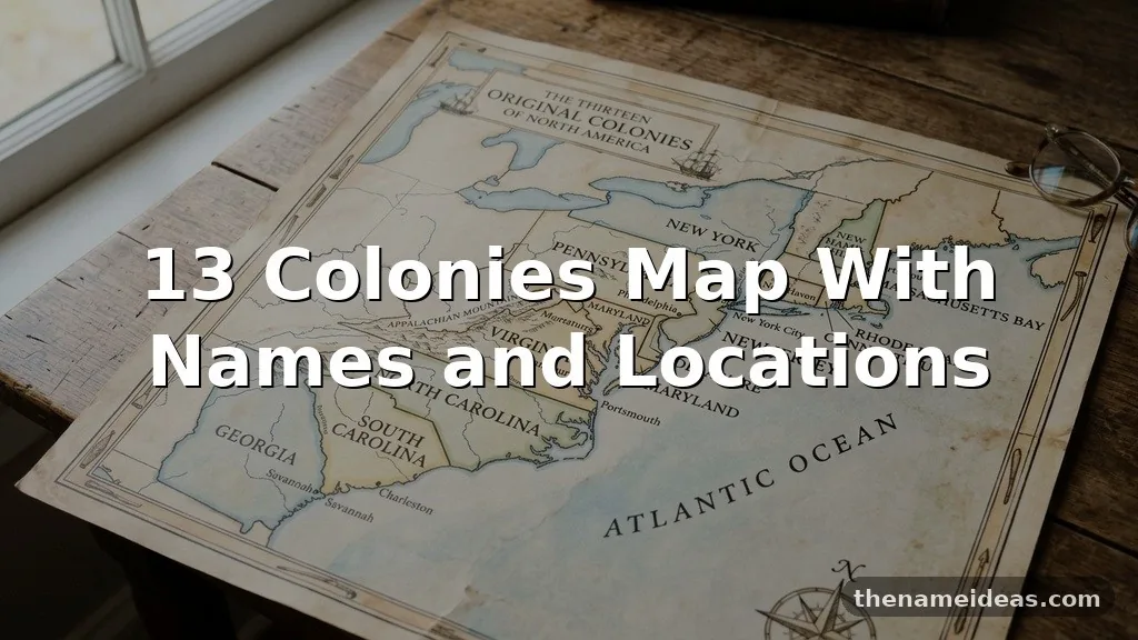
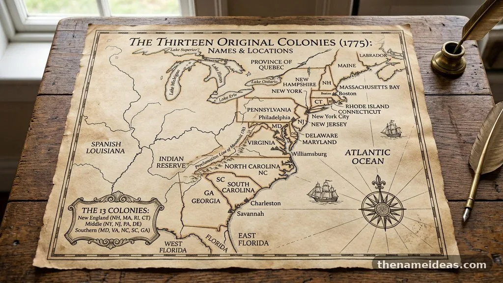
A 13 colonies map with names and locations shows how the original English settlements stretched along the Atlantic coast of North America, from New Hampshire in the north to Georgia in the south. Their positions shaped trade, agriculture, religion, government, and the conflicts that eventually produced the United States.
The colonies are usually grouped into New England, the Middle Colonies, and the Southern Colonies. Understanding those regions makes it easier to place each colony on a map, connect it with its modern state, and follow the road from early settlement to the American Revolution.
What the 13 Colonies Were
The 13 colonies were English settlements established along the eastern seaboard before the American Revolution. They were not all founded at the same time, and they differed sharply in climate, economy, population, religious culture, and relations with Native American communities.
By the 1700s, the colonies formed a long coastal belt between the Atlantic Ocean and the Appalachian Mountains. The Atlantic gave many settlements access to shipping routes, while rivers such as the Chesapeake’s Potomac and the Delaware connected inland farms to port towns.
These colonies were British possessions, but they developed local assemblies and distinct political traditions. Residents generally considered themselves English subjects until disputes over taxation, representation, trade regulations, and imperial authority pushed many colonists toward independence.
The phrase “13 colonies” refers specifically to the colonies that later declared independence in 1776. Other European settlements existed in North America, including French and Spanish colonies, but they were not part of the original thirteen that became the first states of the United States.
| Region | Colonies | General location | Important characteristics |
|---|---|---|---|
| New England | New Hampshire, Massachusetts, Rhode Island, Connecticut | Northeastern Atlantic coast | Rocky land, forests, fishing, shipbuilding, commerce, and town-centered communities |
| Middle Colonies | New York, New Jersey, Pennsylvania, Delaware | Central Atlantic coast | Productive farmland, major rivers, ports, religious diversity, and varied immigrant communities |
| Southern Colonies | Maryland, Virginia, North Carolina, South Carolina, Georgia | Chesapeake and southeastern Atlantic coast | Plantation agriculture, tobacco, rice, indigo, slavery, and warmer growing conditions |
On a classroom map, the colonies appear close together compared with the size of the modern United States. Their locations were nevertheless separated by difficult terrain, slow roads, broad rivers, and long travel times. Geography helped create regional identities that remained important during the colonial period and after independence.
The 13 Colonies in Order
There are several ways to place the colonies “in order.” A historical list may follow founding dates, while a map may arrange them from north to south. The list below uses a commonly taught founding sequence and includes the present-day location associated with each colony.
- Virginia — Established in 1607 around Jamestown; it occupied much of the Chesapeake region and became a major tobacco-producing colony.
- Massachusetts — Plymouth was founded in 1620, followed by the Massachusetts Bay Colony in 1630; Boston became its leading port.
- New Hampshire — Settlements grew along the Piscataqua River and coastal New England, north of Massachusetts.
- Maryland — Founded in 1634 as a proprietary colony north of the Potomac River, it became known for tobacco and religious pluralism.
- Connecticut — English settlements developed along the Connecticut River and Long Island Sound during the 1630s.
- Rhode Island — Founded by religious dissenters, including Roger Williams and Anne Hutchinson, it occupied part of the region around Narragansett Bay.
- Delaware — Settled along Delaware Bay and the Delaware River, it was closely connected to Pennsylvania but retained its own colonial identity.
- North Carolina — Located south of Virginia, it developed scattered coastal and inland settlements with farms, forests, and access to the Atlantic.
- South Carolina — Centered on Charleston and the low-country coast, it became a major producer of rice and indigo.
- New Jersey — Positioned between the Hudson and Delaware Rivers, it included fertile farmland and access to important ports.
- New York — Centered on the Hudson River and New York City, it occupied a strategically important location between New England and the Middle Colonies.
- Pennsylvania — Founded by William Penn in 1681, it extended west from the Delaware River and became a major agricultural and commercial colony.
- Georgia — Established in 1732 and settled in the 1730s, it formed the southern frontier of the British colonies.
The founding order can look different in reference works because some colonies began as grants, settlements, or reorganized jurisdictions before receiving a clearer political identity. For example, Massachusetts includes both the earlier Plymouth settlement and the later Massachusetts Bay government, while Delaware’s colonial history overlaps with Swedish, Dutch, and English control.
New England Colonies on the Map
The New England Colonies were Massachusetts, New Hampshire, Rhode Island, and Connecticut. They occupied the northeastern part of the 13-colony region, where the coastline was irregular and the land was often rocky, forested, and less suited to large-scale plantation agriculture than the Chesapeake or southern low country.
Massachusetts was the region’s political and commercial center. Boston stood on a protected harbor and became an important port for fishing, shipbuilding, trade, and communication with Britain and the Caribbean. Plymouth, founded by Separatists in 1620, was smaller than Boston but became a powerful symbol in later American historical memory.
New Hampshire lay north of Massachusetts, with settlements concentrated near the coast and along the Piscataqua River. The colony’s economy combined fishing, timber, farming, and trade, while its inland areas connected the Atlantic settlements to the forests and waterways of northern New England.
Rhode Island occupied a compact but significant position around Narragansett Bay. Providence, Newport, and other communities supported commerce and maritime activity, and the colony became known for a comparatively broad approach to religious liberty. Its location on the bay gave it access to coastal shipping even though its land area was small.
Connecticut extended along the Connecticut River and the coast of Long Island Sound. Hartford, New Haven, and other settlements developed around fertile river valleys, and the colony became associated with local self-government, agriculture, trade, and a strong network of town communities.
The region’s geography encouraged economic variety rather than dependence on one export crop. Fishing, lumber, shipbuilding, coastal trade, and small farms all mattered. New England’s ports also linked the colonies to the Caribbean, where merchants exchanged food, timber, livestock, and manufactured goods for sugar and other products.
Middle Colonies and Their Central Location
The Middle Colonies were New York, New Jersey, Pennsylvania, and Delaware. On a 13 colonies map, they occupy the central Atlantic corridor between New England and the Chesapeake region. Their position gave them access to major rivers, fertile farmland, inland routes, and some of the busiest ports in British North America.
New York was especially important because the Hudson River created a natural route into the interior. New York City stood at the river’s mouth, while Albany connected the Hudson Valley with routes leading toward the Great Lakes and the upper interior. The colony’s location made it strategically valuable during conflicts involving Britain, France, Native American nations, and rival European powers.
New Jersey lay between the Hudson and Delaware Rivers. Although it had no single port equal to New York City or Philadelphia, its farms supplied nearby urban markets, and its position made it a crossroads for travel and commerce. The colony’s population included English, Dutch, Scottish, German, and other communities.
Pennsylvania was established by William Penn as a proprietary colony in 1681. Philadelphia, founded near the junction of the Delaware and Schuylkill Rivers, quickly became one of the largest cities in colonial America and an important center of printing, trade, politics, and religious life.
Delaware occupied the land and waterways around Delaware Bay and the lower Delaware River. It was sometimes called the “Three Lower Counties” because it was governed alongside Pennsylvania for much of the colonial period, but it maintained its own assembly and later became a separate state.
Religious and cultural diversity was especially visible in the Middle Colonies. Quakers, Anglicans, Presbyterians, Lutherans, Mennonites, Catholics, Jews, and other groups lived in the region. That variety influenced settlement patterns, architecture, farming practices, education, and public debates about religious authority.
Food production was another defining feature. Wheat and other grains grew well in the fertile soils of Pennsylvania, New Jersey, and parts of New York, earning the Middle Colonies a reputation as the “breadbasket” of British North America. The phrase simplifies a complicated economy, but it accurately points to the region’s major agricultural role.
Southern Colonies and Chesapeake Geography
The Southern Colonies were Maryland, Virginia, North Carolina, South Carolina, and Georgia. They stretched across the Chesapeake Bay, the Carolina coast, and the southeastern frontier. Warmer temperatures and longer growing seasons supported export agriculture, although the specific crops and settlement patterns varied from colony to colony.
Virginia was the oldest permanent English colony in the region. Jamestown was established in 1607 along the James River, a location chosen for defensive and commercial reasons. The settlement struggled during its early years, but tobacco cultivation later transformed Virginia’s economy and population.
Maryland was founded in 1634 under the Calvert family. Its location north of the Potomac River placed it beside Virginia and near the Chesapeake’s major waterways. Tobacco became central to the economy, while Maryland’s founding charter and settlement policies made it a notable destination for English Catholics and other colonists seeking religious opportunity.
North Carolina developed more slowly than Virginia and South Carolina. Its settlements were spread across coastal plains, sounds, and inland waterways rather than concentrated around a single dominant city. Small farms, naval stores, timber, livestock, and limited plantation agriculture all contributed to the colony’s economy.
South Carolina was shaped by Charleston and the low-country environment. Rice grew successfully in coastal wetlands, and indigo became another valuable export. These crops depended on enslaved labor, creating a plantation society marked by extreme inequality and a large population of enslaved Africans and African Americans.
Georgia was the last of the thirteen colonies to be established. Its founders initially promoted settlement as a buffer between South Carolina and Spanish Florida, while also presenting the colony as a place for people facing economic hardship. Savannah became its leading early settlement.
The Southern Colonies cannot be understood only through climate or agriculture. Their economic growth depended heavily on forced labor, land expansion, and the displacement of Native American peoples. Relations between colonists and American tribes included trade and diplomacy, but also violence, land disputes, warfare, and treaty conflicts.
How to Read a 13 Colonies Map
A useful map should show more than thirteen labels. It should help viewers see the coastline, major rivers, neighboring colonies, and the broad north-to-south arrangement that shaped movement and trade. Maps may display colonial boundaries differently because borders changed over time and were often disputed.
Start at the top of the map with New Hampshire. Move south through Massachusetts, Rhode Island, and Connecticut, then continue into New York, New Jersey, Pennsylvania, and Delaware. Maryland, Virginia, North Carolina, South Carolina, and Georgia complete the chain along the Atlantic coast.
Modern state boundaries do not perfectly match colonial boundaries. Colonial Virginia, for example, claimed territory that later became Kentucky, West Virginia, and parts of other states. Pennsylvania also extended farther west than the compact shape associated with the modern state.
Colonial maps may include areas labeled with historical names that are unfamiliar today. The Chesapeake Bay, Delaware Bay, Cape Cod, Long Island, the Hudson River, and the Appalachian Mountains are useful reference points because they remain geographically recognizable.
| Map feature | Why it matters | Colonies most closely connected to it |
|---|---|---|
| Atlantic Ocean | Provided routes for migration, trade, military movement, and communication with England | All 13 colonies |
| Chesapeake Bay | Created deep-water access for tobacco exports and connected inland plantations to ocean trade | Maryland and Virginia |
| Delaware River | Supported commerce and linked Philadelphia, Delaware, New Jersey, and inland farms | Pennsylvania, Delaware, and New Jersey |
| Hudson River | Opened a route between New York Harbor and the interior | New York |
| Appalachian Mountains | Created a major geographic barrier between coastal settlements and western lands | Several colonies, especially Virginia and Pennsylvania |
Some maps show only the coastal strip occupied by English settlement, while others include enormous western claims. Both approaches can be accurate if the map identifies its date and purpose. A map of settlement density will look very different from a map of official colonial claims.
When and Why the Colonies Were Established
The colonies emerged from different motives. Investors hoped to earn profits, religious groups sought communities where they could practice their beliefs, and the English government wanted to strengthen its position against France, Spain, the Netherlands, and competing Indigenous powers.
Virginia began as a commercial venture associated with the Virginia Company. Massachusetts grew through both the Plymouth settlement and the Massachusetts Bay enterprise. Maryland was a proprietary project connected to the Calvert family, while Pennsylvania was granted to William Penn.
Georgia’s establishment reflected strategic concerns as well as humanitarian claims. Its position near Spanish Florida gave Britain a defensive interest in the region. The colony also formed part of a broader plan to create new opportunities for settlers who lacked land or employment in Britain.
Colonial development was never a simple empty-land story. Native American nations had established communities, political systems, trade routes, farming traditions, and territorial relationships long before European settlement. Colonists entered existing cultural landscapes and often depended on Indigenous knowledge while simultaneously taking land and expanding settlements.
English law and political ideas also changed across the colonies. Charters, proprietary grants, royal instructions, local assemblies, town meetings, and customary practices all influenced government. The colonies shared an imperial connection, but they did not operate as one unified society.
By the mid-1700s, population growth and economic expansion increased pressure on western lands. The French and Indian War intensified competition among Britain, France, and Native American alliances. Britain’s victory changed the map of North America, but the cost of that war contributed to new taxes and imperial policies that angered many colonists.
From Colonial Regions to the American Revolution
The geography of the thirteen colonies influenced the American Revolution without determining its outcome by itself. Ports such as Boston, New York, Philadelphia, Charleston, and Savannah connected the colonies to the Atlantic economy, while inland farms supplied food and raw materials.
Political resistance grew after the French and Indian War ended in 1763. Britain attempted to raise revenue and strengthen administrative control through measures that many colonists viewed as violations of their rights. Protests against the Stamp Act, Townshend duties, and other policies spread through networks of merchants, printers, assemblies, and local committees.
Regional differences remained important during the crisis. New England had a strong tradition of town politics and resistance to imperial authority.
The Middle Colonies included competing commercial interests and a more diverse population. The Southern Colonies contained powerful planters, enslaved communities, small farmers, and coastal merchants with different stakes in the conflict.
The First Continental Congress met in Philadelphia in 1774, which reflected the Middle Colonies’ central geographic position. The Second Continental Congress later managed the war effort and approved the Declaration of Independence in 1776.
Not everyone in the colonies supported independence. Loyalists remained present in every region, and many Native American nations made decisions based on their own security, diplomacy, and territorial concerns rather than simply choosing a colonial side. Enslaved people also sought freedom through petitions, military service, escape, and negotiations with both British and American forces.
After the war, the thirteen colonies became the original thirteen states. Their colonial boundaries and institutions continued to influence state politics, local culture, and regional identity. The republic that followed inherited both the language of liberty and the deep inequalities of colonial society.
Common Questions About the 13 Colonies
What are the 13 colonies in north-to-south order?
A general north-to-south arrangement is New Hampshire, Massachusetts, Rhode Island, Connecticut, New York, New Jersey, Pennsylvania, Delaware, Maryland, Virginia, North Carolina, South Carolina, and Georgia. Some maps shift the order slightly because colonies had irregular boundaries and some were positioned beside one another rather than in a single straight line.
What was the richest colony?
There was no single measure of wealth, so the answer depends on whether a person means total economic output, port commerce, plantation wealth, or average individual prosperity. Virginia and South Carolina contained extremely wealthy plantation owners, while New York and Pennsylvania developed major commercial centers. Wealth was distributed unevenly, and enslaved people produced much of the agricultural value without receiving its benefits.
What was North America called before the 13 colonies?
North America had no single name used by all of its inhabitants before the thirteen colonies existed. Indigenous nations had their own names for regions, rivers, and homelands, while European powers described the continent through competing imperial maps. “British North America” became a later term for British-controlled territories, not a name used by every earlier resident.
Were the 13 colonies all founded by England?
They became English or British colonies, but several areas had earlier Dutch, Swedish, or Indigenous histories. New York, New Jersey, Delaware, and Pennsylvania are especially connected to earlier Dutch or Swedish settlements and claims before English control became dominant. Colonial identity developed through conquest, transfers, migration, and political reorganization.
Where can I find a reliable historical map?
For a source that combines historical context with primary materials, the Library of Congress collection on colonial settlement is a useful starting point. When comparing maps, check the date, the mapmaker, the boundaries shown, and whether the map depicts actual settlement or territorial claims.
Why the Map Still Matters
A map turns a memorized list into a geographic explanation. It shows why New England developed around ports and town communities, why the Middle Colonies became commercial and agricultural centers, and why the Chesapeake and southern colonies relied so heavily on export crops and coerced labor.
It also clarifies the distances involved in colonial life. A message from Boston to Charleston required time by sea or overland travel, and political cooperation was difficult across such a long coastline. The colonies shared language and imperial institutions, but their daily experiences were shaped by local climate, rivers, economies, and cultures.
Historical maps should also be read critically. Colonial labels can make Indigenous homelands disappear, while boundary lines may suggest that European governments controlled land more fully than they actually did. Pairing a colonies map with information about Native American nations, African diasporic communities, and European empires gives a more complete picture.
For students, the most effective approach is to learn the regional pattern first, then attach each colony to a recognizable geographic feature. Remembering Boston, the Hudson River, Philadelphia, the Chesapeake Bay, Charleston, and Savannah creates a mental framework that makes the individual names easier to place.
Conclusion
A 13 colonies map with names and locations reveals more than where thirteen settlements appeared along the Atlantic coast. It connects geography with trade, religion, farming, slavery, Native American history, imperial rivalry, and the political arguments that led to the American Revolution.
Use the regional divisions as your starting point, then compare founding dates, major waterways, and modern state boundaries. Once those relationships are clear, the map becomes a practical way to understand how separate colonies became the first states of the United States.